3 in 30 - 2000.07.15

Heavy traffic on Hwy 16!
The day is hot and humid, overcast with a slight chance of rain, so being outside, riding around on my bicycle is more pleasant than being inside. So, I rode to the southwest corner of the boundaries of our neighborhood and snapped these images at around two in the afternoon on Saturday.
The corner is the intersection of highway 16 and Midori kaido. Highway 16 is somewhat of a beltway around Tokyo at a distance of about 45 kilometers from the center of the city. As a result, it is a busy highway. In most places, it is a four lane highway, but in our city of Akishima, is reduced to two lanes. This creates in a lot of local traffic congestion. It is one of the reasons why it can take us as little as 10 minutes to drive home from work, or as long at 45 minutes to drive the 2-1/2 kilometers.
Midori means green or verdant and may be so named for the vegetable gardens that used to be in this area. It is probably not the reason for the green guard railing though many neighborhoods each have their own distinctive street lamps.
At the left of the picture is an older style lumber store with pieces of wood stacked vertically. There are also some small bundles of wood that can be burned. On the highway are a couple of dump trucks, a pizza delivery motorscooter and a car that has entered the intersection while the light was yellow. There is probably another car behind it completely blocking everyone else entering the highway.

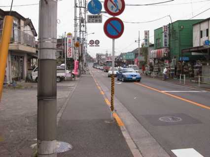
Looking north on Hwy 16
From the same corner, a few moments later, looking back the other direction to the north. In the distance, you can see a new 12-story apartment building that was built right between highway 16 and on the street out from the train station. To give you an idea of the western edge of Matsubara-cho, this apartment building faces the street that would be the northwest corner of our neighborhood.
On a clear day, the people living in the western units of this apartment day must have a magnificent view of Mt. Fuji. Clear summer days are a rarity.
Looking at traffic backed up on Midori kaido
Again from the same corner only moments later is this view back up Midori kaido. The cars are backed up for at least a block trying to get onto highway 16. There is a slight rise of about five meters from this corner to the rest of the neighborhood. Not too far to the south of us is the Tama River, so from where we live, to the south it drops down to the river and to the north rises to a level plain where Yokota Air Base is located.
Obviously noted by western eyes is the presence of overhead wires. Most of the utility companies in the US have gone underground, so only rarely do you see telephone poles, electrical poles and the wiring that hangs from them. I can only speculate about the overhead wiring here in Japan.
One reason might be that this is an earthquake prone island so above ground utilities may be easier to maintain. Another might be that the rapid growth of the whole Tokyo area necessitated the quickest method of getting utilities out to people. There is probably no building in any of these pictures that is older than about 25 years old. Before that, most of this would have been farm land, small plots of vegetables and grains owned by numerous individuals. Getting the "right-of-way" to put in utilities would have been a monumental task. As an example, Narita International Airport has been trying for decades to put in a second runway but has been thwarted in their efforts by numerous farmland owners. It seems the idea of eminent domain is not popularly supported in Japan. Such was not always the case in Japan's history.